
Make a donation
Montecito Peak topographic map
Click on the map to display elevation.
Make a donation
About this map
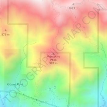
Name: Montecito Peak topographic map, elevation, terrain.
Average elevation: 709 m
Minimum elevation: 275 m
Maximum elevation: 1,105 m
Make a donation
Other topographic maps
Click on a map to view its topography, its elevation and its terrain.
Santa Barbara
United States > California > Santa Barbara County
Annual rainfall totals are highly variable and in exceptional years like 1940–1941 and 1997–1998 over 40 inches (1.0 m) of rain have fallen in a year, but in dry seasons less than 6 inches (150 mm) is not unheard of. Snow sometimes covers higher elevations of the Santa Ynez Mountains but is extremely rare…
Average elevation: 119 m
Make a donation
Goleta
United States > California > Santa Barbara County
The Goleta Valley is a coastal plain, approximately three miles (4.8 km) across, between the Santa Ynez Mountains, the principal mountain range of southern Santa Barbara County, and the Pacific Ocean. It consists of Holocene and Pleistocene alluvium, colluvium, estuarine deposits, as well as marine terraces…
Average elevation: 57 m
Make a donation
Channel Islands National Park
United States > California > Santa Barbara County
Average elevation: 9 m
Vandenberg Village
United States > California > Santa Barbara County > Lompoc
Average elevation: 132 m
Make a donation
Isla Vista
United States > California > Santa Barbara County
Isla Vista is an unincorporated community and census-designated place (CDP) in Santa Barbara County, California in the United States. As of 2020 census, the community had a population of 15,500. The majority of residents are college students at the University of California, Santa Barbara or at Santa Barbara…
Average elevation: 6 m
Make a donation
Channel Islands
United States > California > Santa Barbara County
The Channel Islands at low elevations are virtually frost-free and constitute one of the few such areas in the 48 contiguous US states. It snows only rarely on higher mountain peaks.
Average elevation: 4 m
Channel Islands
United States > California > Santa Barbara County
The Channel Islands at low elevations are virtually frost-free and constitute one of the few such areas in the 48 contiguous US states. It snows only rarely, on higher mountain peaks.
Average elevation: 4 m
Make a donation
Channel Islands National Park
United States > California > Santa Barbara County
Average elevation: 9 m
Mission Canyon
United States > California > Santa Barbara County
The approximate center of Mission Canyon is located at 34°26′59″N 119°42′59″W / 34.44972°N 119.71639°W / 34.44972; -119.71639 (34.449797, -119.716315). Situated along the southern facing slopes of the Santa Ynez Mountains, Mission Canyon measures some 1,122 acres comprising an estimated…
Average elevation: 199 m
Shoreline Park
United States > California > Santa Barbara County > Santa Barbara
Average elevation: 21 m
Make a donation
Jalama Beach County Park
United States > California > Santa Barbara County > Jalama
Average elevation: 40 m
Make a donation
Santa Barbara
United States > California > Santa Barbara County
Annual rainfall totals are highly variable and in exceptional years (like 1940–1941 and 1997–1998) over 40 inches (1,000 mm) of rain have fallen in a year, but in dry seasons less than 6 inches (150 mm) is not unheard of. Snow sometimes covers higher elevations of the Santa Ynez Mountains but is extremely…
Average elevation: 119 m
Santa Barbara
United States > California > Santa Barbara County
Annual rainfall totals are highly variable and in exceptional years like 1940–1941 and 1997–1998 over 40 inches (1.0 m) of rain have fallen in a year, but in dry seasons less than 6 inches (150 mm) is not unheard of. Snow sometimes covers higher elevations of the Santa Ynez Mountains but is extremely rare…
Average elevation: 119 m
Make a donation
Santa Barbara
United States > California > Santa Barbara County
Annual rainfall totals are highly variable and in exceptional years (like 1940–1941 and 1997–1998) over 40 inches (1,000 mm) of rain have fallen in a year, but in dry seasons less than 6 inches (150 mm) is not unheard of. Snow sometimes covers higher elevations of the Santa Ynez Mountains but is extremely…
Average elevation: 119 m
Santa Barbara
United States > California > Santa Barbara County
Annual rainfall totals are highly variable and in exceptional years (like 1940–1941 and 1997–1998) over 40 inches (1,000 mm) of rain have fallen in a year, but in dry seasons less than 6 inches (150 mm) is not unheard of. Snow sometimes covers higher elevations of the Santa Ynez Mountains but is extremely…
Average elevation: 119 m
Make a donation
Goleta
United States > California > Santa Barbara County
The Goleta Valley is a coastal plain, approximately three miles (4.8 km) across, between the Santa Ynez Mountains, the principal mountain range of southern Santa Barbara County, and the Pacific Ocean. It consists of Holocene and Pleistocene alluvium, colluvium, estuarine deposits, as well as marine terraces…
Average elevation: 57 m
Make a donation
Isla Vista
United States > California > Santa Barbara County
Isla Vista (Spanish for "View Island") is an unincorporated community and census-designated place (CDP) in Santa Barbara County, California in the United States. As of 2020 census, the community had a population of 15,500. The majority of residents are college students at the University of California, Santa…
Average elevation: 6 m