
Thank you for supporting this site ❤️
Make a donation
Make a donation
Farvagny topographic map
Click on the map to display elevation.
Thank you for supporting this site ❤️
Make a donation
Make a donation
About this map
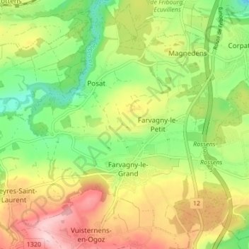
Name: Farvagny topographic map, elevation, terrain.
Location: Farvagny, Gibloux, District de la Sarine, Fribourg, 1726, Suisse (46.70582 7.03786 46.75218 7.09060)
Average elevation: 714 m
Minimum elevation: 600 m
Maximum elevation: 856 m
Thank you for supporting this site ❤️
Make a donation
Make a donation
Other topographic maps
Click on a map to view its topography, its elevation and its terrain.