
Make a donation
Birkwood topographic map
Click on the map to display elevation.
Make a donation
About this map
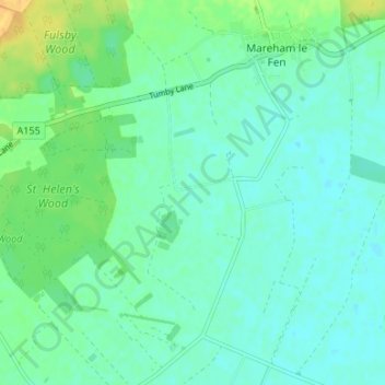
Name: Birkwood topographic map, elevation, terrain.
Average elevation: 8 m
Minimum elevation: 0 m
Maximum elevation: 27 m
Make a donation
Other topographic maps
Click on a map to view its topography, its elevation and its terrain.
Skegness
United Kingdom > England > Lincolnshire > East Lindsey
Skegness fronts the North Sea. It is located on a low-lying flat region called Lincoln Marsh, which runs along the coast between Skegness and the Humber and separates the coast from the upland Wolds. Much of the parish's elevation is close to sea level, although a narrow band along the seafront is 4–5 m…
Average elevation: 2 m
Make a donation
Frithville and Westville
United Kingdom > England > Lincolnshire > East Lindsey
Average elevation: 3 m
The Lymn
United Kingdom > England > Lincolnshire > East Lindsey > Thorpe St. Peter
Average elevation: 2 m
Make a donation
Make a donation
Make a donation
Holton le Clay
United Kingdom > England > Lincolnshire > East Lindsey > Holton le Clay
Average elevation: 14 m
Make a donation
Make a donation
Make a donation
Make a donation
Mareham le Fen
United Kingdom > England > Lincolnshire > East Lindsey > Mareham le Fen
Average elevation: 8 m
Make a donation
Make a donation
Wainfleet All Saints
United Kingdom > England > Lincolnshire > East Lindsey > Wainfleet St Mary
Average elevation: 3 m
Wainfleet Haven
United Kingdom > England > Lincolnshire > East Lindsey > Wainfleet Clough
Average elevation: 3 m
Make a donation
North Thoresby
United Kingdom > England > Lincolnshire > East Lindsey > North Thoresby
Average elevation: 26 m
Theddlethorpe All Saints
United Kingdom > England > Lincolnshire > East Lindsey > Theddlethorpe St Helen
Average elevation: 2 m
Make a donation
Make a donation
Louth Navigation
United Kingdom > England > Lincolnshire > East Lindsey > Alvingham
Average elevation: 8 m
Saltfleetby
United Kingdom > England > Lincolnshire > East Lindsey > Saltfleetby St Peter
Average elevation: 2 m
Make a donation
Hagworthingham
United Kingdom > England > Lincolnshire > East Lindsey > Hagworthingham
Average elevation: 70 m
Make a donation
North Somercotes
United Kingdom > England > Lincolnshire > East Lindsey > North Somercotes
Average elevation: 1 m
Make a donation
Great Steeping
United Kingdom > England > Lincolnshire > East Lindsey > Great Steeping
Average elevation: 9 m
Yarburgh
United Kingdom > England > Lincolnshire > East Lindsey > Covenham St. Mary
Average elevation: 11 m
Make a donation
Little Carlton
United Kingdom > England > Lincolnshire > East Lindsey > Little Carlton
Average elevation: 11 m
Make a donation
Maltby le Marsh
United Kingdom > England > Lincolnshire > East Lindsey > Maltby Le Marsh
Average elevation: 4 m
Make a donation
Make a donation
Make a donation
Halton Holegate
United Kingdom > England > Lincolnshire > East Lindsey > Halton Holegate
Average elevation: 13 m
Make a donation
Toynton St Peter
United Kingdom > England > Lincolnshire > East Lindsey > Toynton St Peter
Average elevation: 9 m
Make a donation
Woodhall Spa
United Kingdom > England > Lincolnshire > East Lindsey > Woodhall Spa
Average elevation: 9 m
Make a donation
Farlesthorpe
United Kingdom > England > Lincolnshire > East Lindsey > Alford > Farlesthorpe
Average elevation: 5 m
Benniworth
United Kingdom > England > Lincolnshire > East Lindsey > Benniworth
Average elevation: 82 m
Make a donation