
Thank you for supporting this site ❤️
Make a donation
Make a donation
Le Douy topographic map
Click on the map to display elevation.
Thank you for supporting this site ❤️
Make a donation
Make a donation
About this map
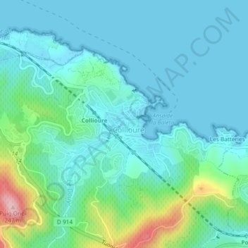
Name: Le Douy topographic map, elevation, terrain.
Average elevation: 45 m
Minimum elevation: -1 m
Maximum elevation: 238 m
Thank you for supporting this site ❤️
Make a donation
Make a donation
Other topographic maps
Click on a map to view its topography, its elevation and its terrain.
Château Royal de Collioure
France > Occitanie > Pyrénées-Orientales > Collioure
Average elevation: 41 m