
Thank you for supporting this site ❤️
Make a donation
Make a donation
Palana topographic map
Click on the map to display elevation.
Thank you for supporting this site ❤️
Make a donation
Make a donation
About this map
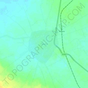
Name: Palana topographic map, elevation, terrain.
Location: Palana, Bikaner Tehsil, Bikaner, Rajasthan, 334402, India (27.82567 73.24383 27.86567 73.28383)
Average elevation: 266 m
Minimum elevation: 259 m
Maximum elevation: 281 m
Thank you for supporting this site ❤️
Make a donation
Make a donation
Other topographic maps
Click on a map to view its topography, its elevation and its terrain.