
Kefallonia Regional Unit topographic map
Interactive map
Click on the map to display elevation.
About this map
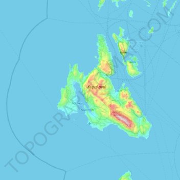
Name: Kefallonia Regional Unit topographic map, elevation, terrain.
Average elevation: 49 m
Minimum elevation: 0 m
Maximum elevation: 1,601 m
Other topographic maps
Click on a map to view its topography, its elevation and its terrain.
Kefalonia
Greece > Peloponnese, West Greece and Ionian Sea
Kefalonia, Δήμος Κεφαλληνίας, Kefallonia Regional Unit, Ionian Islands Region, Peloponnese, West Greece and Ionian Sea, Greece
Average elevation: 60 m
Zakynthos
Greece > Peloponnese, West Greece and Ionian Sea > Zakynthos
Zakynthos, Zante Municipality, Zakynthos Regional Unit, Ionian Islands Region, Peloponnese, West Greece and Ionian Sea, 29100, Greece
Average elevation: 23 m
Κοινότητα Νέας Τίρυνθας
Greece > Peloponnese, West Greece and Ionian Sea > Kapodistrias
Κοινότητα Νέας Τίρυνθας, Kapodistrias, Δήμος Ναυπλιέων, Argolis Regional Unit, Peloponnese Region, Peloponnese, West Greece and Ionian Sea, 21100, Greece
Average elevation: 21 m
Kalamata
Greece > Peloponnese, West Greece and Ionian Sea > Kalamata
Kalamata, Δήμος Καλαμάτας, Messenia Regional Unit, Peloponnese Region, Peloponnese, West Greece and Ionian Sea, 24100, Greece
Average elevation: 425 m
Mount Ainos
Greece > Peloponnese, West Greece and Ionian Sea
Mount Ainos, Δήμος Κεφαλληνίας, Kefallonia Regional Unit, Ionian Islands Region, Peloponnese, West Greece and Ionian Sea, Greece
Average elevation: 1,234 m
Highest Point
Greece > Peloponnese, West Greece and Ionian Sea
Highest Point, Δήμος Παξών, Corfu Regional Unit, Ionian Islands Region, Peloponnese, West Greece and Ionian Sea, 49082, Greece
Average elevation: 99 m