
Thank you for supporting this site ❤️
Make a donation
Make a donation
Southport topographic map
Click on the map to display elevation.
Thank you for supporting this site ❤️
Make a donation
Make a donation
About this map
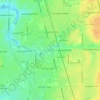
Name: Southport topographic map, elevation, terrain.
Average elevation: 236 m
Minimum elevation: 219 m
Maximum elevation: 253 m
Thank you for supporting this site ❤️
Make a donation
Make a donation
Other topographic maps
Click on a map to view its topography, its elevation and its terrain.
Dawson Lake
United States > Indiana > Marion County > Indianapolis > Shore Acres
Average elevation: 225 m
White River
United States > Indiana > Marion County > Indianapolis > Ravenswood
Average elevation: 227 m
Fort Harrison State Park
United States > Indiana > Marion County > Indianapolis
Average elevation: 251 m
Thank you for supporting this site ❤️
Make a donation
Make a donation