
Thank you for supporting this site ❤️
Make a donation
Make a donation
Kannauj topographic map
Click on the map to display elevation.
Thank you for supporting this site ❤️
Make a donation
Make a donation
Kannauj
Kannauj is located at 27°04′N 79°55′E / 27.07°N 79.92°E / 27.07; 79.92. It has an average elevation of 139 metres (456 feet).
Thank you for supporting this site ❤️
Make a donation
Make a donation
About this map
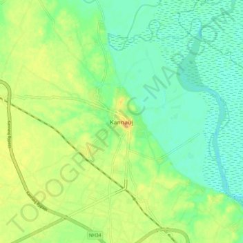
Name: Kannauj topographic map, elevation, terrain.
Location: Kannauj, Uttar Pradesh, 209725, India (27.01363 79.88017 27.09363 79.96017)
Average elevation: 135 m
Minimum elevation: 123 m
Maximum elevation: 149 m
Thank you for supporting this site ❤️
Make a donation
Make a donation