
Thank you for supporting this site ❤️
Make a donation
Make a donation
Rabenshof topographic map
Click on the map to display elevation.
Thank you for supporting this site ❤️
Make a donation
Make a donation
Rabenshof
Das in der Hersbrucker Alb gelegene Dorf befindet sich zweieinhalb Kilometer östlich des Ortszentrums von Schnaittach und liegt auf einer Höhe von 461 m ü. NHN.
Thank you for supporting this site ❤️
Make a donation
Make a donation
About this map
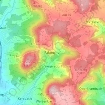
Name: Rabenshof topographic map, elevation, terrain.
Average elevation: 462 m
Minimum elevation: 344 m
Maximum elevation: 572 m
Thank you for supporting this site ❤️
Make a donation
Make a donation
Other topographic maps
Click on a map to view its topography, its elevation and its terrain.