
Make a donation
La Estacada topographic map
Click on the map to display elevation.
Make a donation
About this map
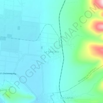
Name: La Estacada topographic map, elevation, terrain.
Average elevation: 2,086 m
Minimum elevation: 2,016 m
Maximum elevation: 2,435 m
Make a donation
Other topographic maps
Click on a map to view its topography, its elevation and its terrain.
Querétaro
Mexico > Querétaro > Municipio de Querétaro
The municipality has rolling hills, mountain ranges and flatlands. Most of the rolling hills cross the territory from south to north, paralleling the Querétaro-San Luis Potosí highway. Most plains are located in the north, and are of sedimentary soil with some protrusions of volcanic rock. Altitude varies…
Average elevation: 1,921 m
Querétaro
Mexico > Querétaro > Municipio de Querétaro
The municipality has rolling hills, mountain ranges and flatlands. Most of the rolling hills cross the territory from south to north, paralleling the Querétaro-San Luis Potosí highway. Most plains are located in the north, and are of sedimentary soil with some protrusions of volcanic rock. Altitude varies…
Average elevation: 1,926 m
Parque Queretaro 2000
Mexico > Querétaro > Municipio de Querétaro > Querétaro
Average elevation: 1,853 m
Make a donation
Delegación Josefa Vergara y Hernández
Mexico > Querétaro > Municipio de Querétaro
Average elevation: 1,958 m
Make a donation
Delegación Josefa Vergara y Hernández
Mexico > Querétaro > Municipio de Querétaro
Average elevation: 1,958 m
Querétaro
Mexico > Querétaro > Municipio de Querétaro
The municipality has rolling hills, mountain ranges and flatlands. Most of the rolling hills cross the territory from south to north, paralleling the Querétaro-San Luis Potosí highway. Most plains are located in the north, and are of sedimentary soil with some protrusions of volcanic rock. Altitude varies…
Average elevation: 1,921 m