
Oberwald topographic map
Interactive map
Click on the map to display elevation.
About this map
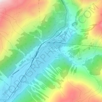
Name: Oberwald topographic map, elevation, terrain.
Location: Oberwald, Obergoms, Goms, Valais/Wallis, 3999, Zwitserland (46.51286 8.33205 46.55286 8.37205)
Average elevation: 1,744 m
Minimum elevation: 1,350 m
Maximum elevation: 2,496 m
Other topographic maps
Click on a map to view its topography, its elevation and its terrain.
Rhonegletscher
Zwitserland > Valais/Wallis > Goms > Obergoms
Rhonegletscher, Obergoms, Goms, Verwaltungsregion Oberland, Valais/Wallis, Zwitserland
Average elevation: 2,805 m
Gletsch
Zwitserland > Valais/Wallis > Goms > Obergoms
Gletsch, Obergoms, Goms, Valais/Wallis, 3999, Zwitserland
Average elevation: 2,090 m
Obergesteln
Zwitserland > Valais/Wallis > Goms > Obergoms
Obergesteln, Obergoms, Goms, Valais/Wallis, 3988, Zwitserland
Average elevation: 1,664 m