
Thank you for supporting this site ❤️
Make a donation
Make a donation
Bandundu topographic map
Click on the map to display elevation.
Thank you for supporting this site ❤️
Make a donation
Make a donation
About this map
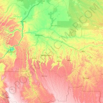
Name: Bandundu topographic map, elevation, terrain.
Location: Bandundu, Democratic Republic of the Congo (-8.13104 15.89472 -0.69543 21.00530)
Average elevation: 555 m
Minimum elevation: 256 m
Maximum elevation: 1,325 m
Thank you for supporting this site ❤️
Make a donation
Make a donation
Other topographic maps
Click on a map to view its topography, its elevation and its terrain.