
Malaire topographic map
Interactive map
Click on the map to display elevation.
About this map
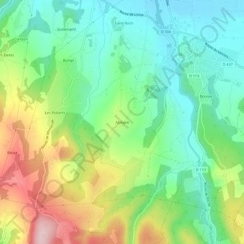
Name: Malaire topographic map, elevation, terrain.
Average elevation: 248 m
Minimum elevation: 141 m
Maximum elevation: 445 m
Other topographic maps
Click on a map to view its topography, its elevation and its terrain.
Boisset
France > Auvergne-Rhône-Alpes > Drôme > Grane
Boisset, Grane, Die, Drôme, Auvergne-Rhône-Alpes, France métropolitaine, 26400, France
Average elevation: 202 m
Les Roberts
France > Auvergne-Rhône-Alpes > Drôme > Grane > Les Roberts
Les Roberts, Grane, Die, Drôme, Auvergne-Rhône-Alpes, France métropolitaine, 26400, France
Average elevation: 272 m