
Make a donation
Sidcup topographic map
Click on the map to display elevation.
Make a donation
About this map
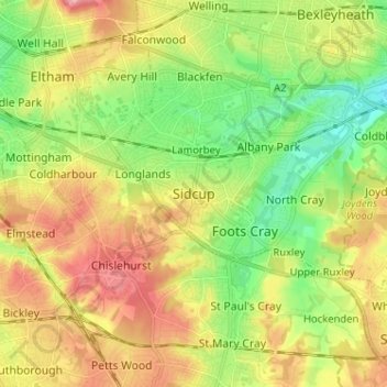
Name: Sidcup topographic map, elevation, terrain.
Location: Sidcup, Greater London, England, DA14 6DH, United Kingdom (51.38640 0.06104 51.46640 0.14104)
Average elevation: 56 m
Minimum elevation: 6 m
Maximum elevation: 117 m
Make a donation
Other topographic maps
Click on a map to view its topography, its elevation and its terrain.
Make a donation
Hyde Park
United Kingdom > England > London
"It consists of a screen of handsome fluted Ionic columns, with three carriage entrance archways, two-foot entrances, a lodge, etc. The extent of the whole frontage is about 107 ft (33 m). The central entrance has a bold projection: the entablature is supported by four columns; and the volutes of the capitals…
Average elevation: 25 m
Make a donation
Make a donation
Lydney Harbour
United Kingdom > England > Gloucestershire > Forest of Dean > Lydney > Naas
Average elevation: 7 m
Make a donation
Epsom and Ewell
United Kingdom > England > Surrey
The borough is at a range of elevations, scaling the lower slopes of the North Downs and drains into a large stream which springs above the surface in Ewell, the Hogsmill River which drains into the Thames at Kingston. The borough comprises.
Average elevation: 73 m
Make a donation
Marlborough
United Kingdom > England > Wiltshire
Marlborough has an oceanic climate somewhat influenced by its inland position and at 407 feet (124 m) elevation is more prone to frost than southern coastal areas. For example, in 1909 the town reported the equal lowest temperature in the UK at a station below 1,600 feet (500 m) for that year, with a…
Average elevation: 163 m
Make a donation
Make a donation
Make a donation
Make a donation
Make a donation
Wolverhampton
United Kingdom > England > West Midlands Combined Authority > Wolverhampton
Average elevation: 138 m
Make a donation
Make a donation