
Thank you for supporting this site ❤️
Make a donation
Make a donation
Churchill Butte topographic map
Click on the map to display elevation.
Thank you for supporting this site ❤️
Make a donation
Make a donation
About this map
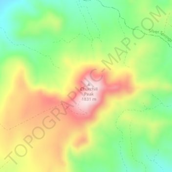
Name: Churchill Butte topographic map, elevation, terrain.
Location: Churchill Butte, Lyon County, Nevada, 89429, United States (39.33931 -119.29605 39.33941 -119.29595)
Average elevation: 1,645 m
Minimum elevation: 1,484 m
Maximum elevation: 1,836 m
Thank you for supporting this site ❤️
Make a donation
Make a donation
Other topographic maps
Click on a map to view its topography, its elevation and its terrain.
Yerington
United States > Nevada > Lyon County
During the summer, temperatures are generally hot to very hot in the afternoon, but the high altitude and low humidity means temperature drop to a comfortable level at night. On average, 8.0 afternoons each summer will exceed 100 °F or 37.8 °C and 73.2 afternoons reach 90 °F (32.2 °C). It is rare, though,…
Average elevation: 1,358 m