
Thank you for supporting this site ❤️
Make a donation
Make a donation
Chatham topographic map
Click on the map to display elevation.
Thank you for supporting this site ❤️
Make a donation
Make a donation
About this map
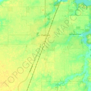
Name: Chatham topographic map, elevation, terrain.
Location: Chatham, Sangamon County, Illinois, 62629, United States (39.63277 -89.72837 39.70332 -89.65138)
Average elevation: 183 m
Minimum elevation: 169 m
Maximum elevation: 190 m
Thank you for supporting this site ❤️
Make a donation
Make a donation
Other topographic maps
Click on a map to view its topography, its elevation and its terrain.