
Bhamo District topographic map
Interactive map
Click on the map to display elevation.
About this map
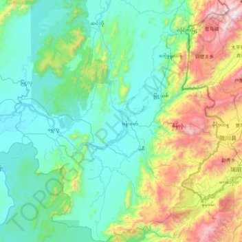
Name: Bhamo District topographic map, elevation, terrain.
Location: Bhamo District, Kachin, Myanmar (23.63325 96.54904 24.90498 97.76921)
Average elevation: 551 m
Minimum elevation: 89 m
Maximum elevation: 2,633 m
Other topographic maps
Click on a map to view its topography, its elevation and its terrain.
Putao Township
Myanmar > Kachin > Putao Township > Putao Township
Putao Township, Putao District, Kachin, 01051, Myanmar
Average elevation: 1,555 m
Hkakabo Razi
Myanmar > Kachin > Nawngmun Township
Hkakabo Razi, Nawngmun Township, Putao District, Kachin, Myanmar
Average elevation: 4,869 m