
Hillsdale topographic map
Interactive map
Click on the map to display elevation.
About this map
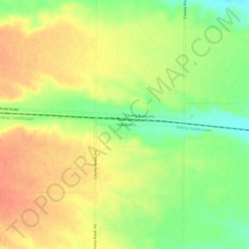
Name: Hillsdale topographic map, elevation, terrain.
Location: Hillsdale, Laramie County, Wyoming, 82060, United States (41.19276 -104.49746 41.23276 -104.45746)
Average elevation: 1,730 m
Minimum elevation: 1,702 m
Maximum elevation: 1,751 m
Other topographic maps
Click on a map to view its topography, its elevation and its terrain.
Cheyenne
United States > Wyoming > Laramie County
Cheyenne, Laramie County, Wyoming, United States
Average elevation: 1,871 m
Ranchettes
United States > Wyoming > Laramie County > Cheyenne
Ranchettes, Cheyenne, Laramie County, Wyoming, 82009, United States
Average elevation: 1,869 m
Pine Bluffs
United States > Wyoming > Laramie County
Pine Bluffs, Laramie County, Wyoming, 82082, United States
Average elevation: 1,549 m
South Greeley
United States > Wyoming > Laramie County > Cheyenne
South Greeley, Cheyenne, Laramie County, Wyoming, 82007, United States
Average elevation: 1,847 m
Burns
United States > Wyoming > Laramie County
Burns, Laramie County, Wyoming, United States
Average elevation: 1,672 m
Cheyenne
United States > Wyoming > Laramie County > Cheyenne
Cheyenne, Laramie County, Wyoming, 82002, United States
Average elevation: 1,891 m
Sloans Lake
United States > Wyoming > Laramie County > Cheyenne
Sloans Lake, Cheyenne, Laramie County, Wyoming, United States
Average elevation: 1,871 m