
Thank you for supporting this site ❤️
Make a donation
Make a donation
Gaberndorf topographic map
Click on the map to display elevation.
Thank you for supporting this site ❤️
Make a donation
Make a donation
About this map
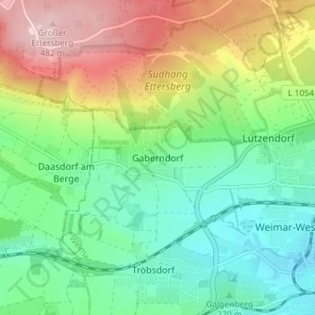
Name: Gaberndorf topographic map, elevation, terrain.
Location: Gaberndorf, Weimar, Thüringen, 99427, Deutschland (50.97777 11.26052 51.01777 11.30052)
Average elevation: 316 m
Minimum elevation: 224 m
Maximum elevation: 481 m
Thank you for supporting this site ❤️
Make a donation
Make a donation
Other topographic maps
Click on a map to view its topography, its elevation and its terrain.
Ilmpark
Deutschland > Thüringen > Weimar
Bemerkenswert ist auch das Haus Ithaka, das 1907 für den Dichter Ernst von Wildenbruch vom Architekten Paul Schultze-Naumburg auf einer Anhöhe oberhalb des Osthanges erbaut wurde, welches einen Blick auf den Park hatte. Diese Blickbeziehung ist jedoch ab 1997 unterhalb der Villa durch Investorenarchitektur…
Average elevation: 243 m
Thank you for supporting this site ❤️
Make a donation
Make a donation