
Thank you for supporting this site ❤️
Make a donation
Make a donation
Bartonville topographic map
Click on the map to display elevation.
Thank you for supporting this site ❤️
Make a donation
Make a donation
About this map
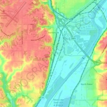
Name: Bartonville topographic map, elevation, terrain.
Location: Bartonville, Peoria County, Illinois, 61607, United States (40.60417 -89.70820 40.66788 -89.61190)
Average elevation: 165 m
Minimum elevation: 132 m
Maximum elevation: 205 m
Thank you for supporting this site ❤️
Make a donation
Make a donation
Other topographic maps
Click on a map to view its topography, its elevation and its terrain.