
Thank you for supporting this site ❤️
Make a donation
Make a donation
Hetzendorf topographic map
Click on the map to display elevation.
Thank you for supporting this site ❤️
Make a donation
Make a donation
Hetzendorf
Das Dorf im Norden der Pegnitz-Kuppenalb befindet sich etwa zwei Kilometer südwestlich des Ortszentrums von Betzenstein auf einer Höhe von 500 m ü. NHN.
Thank you for supporting this site ❤️
Make a donation
Make a donation
About this map
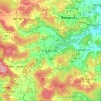
Name: Hetzendorf topographic map, elevation, terrain.
Average elevation: 533 m
Minimum elevation: 460 m
Maximum elevation: 612 m
Thank you for supporting this site ❤️
Make a donation
Make a donation