
Make a donation
Truro topographic map
Click on the map to display elevation.
Make a donation
About this map
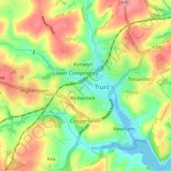
Name: Truro topographic map, elevation, terrain.
Location: Truro, Cornwall, England, United Kingdom (50.24724 -5.09273 50.28014 -5.02389)
Average elevation: 49 m
Minimum elevation: -1 m
Maximum elevation: 111 m
Make a donation
Other topographic maps
Click on a map to view its topography, its elevation and its terrain.
Porthnavas Creek
United Kingdom > England > Cornwall > Porth Navas > Budock Vean
Average elevation: 40 m
Make a donation
Make a donation
Make a donation
Make a donation
Make a donation
Bude
United Kingdom > England > Cornwall
Its earlier importance was as a harbour, and then a source of sea sand useful for improving the inland soil. This was transported on the Bude Canal. The Victorians favoured it as a seaside resort. With new rail links, it became a popular seaside destination in the 20th century. Bradshaw's Guide of 1866,…
Average elevation: 39 m
Battle of Braddock Down
United Kingdom > England > Cornwall > Lanreath > Bocaddon
Average elevation: 138 m
Make a donation
Make a donation
Make a donation
Make a donation
Saint Michael's Mount
United Kingdom > England > Cornwall > Marazion > St Michael's Mount
Average elevation: 6 m
Make a donation
Make a donation
Make a donation
Make a donation
Make a donation
Make a donation
Make a donation
Make a donation
Make a donation
Make a donation
Make a donation
Make a donation
Make a donation
Bude
United Kingdom > England > Cornwall
Its earlier importance was as a harbour, and then a source of sea sand useful for improving the inland soil. This was transported on the Bude Canal. The Victorians favoured it as a seaside resort. With new rail links, it became a popular seaside destination in the 20th century. Bradshaw's Guide of 1866,…
Average elevation: 39 m
Make a donation
Make a donation
Make a donation