
Thank you for supporting this site ❤️
Make a donation
Make a donation
Crouzilhac topographic map
Click on the map to display elevation.
Thank you for supporting this site ❤️
Make a donation
Make a donation
About this map
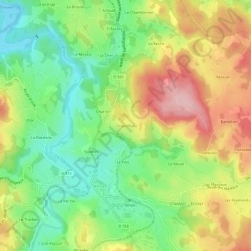
Name: Crouzilhac topographic map, elevation, terrain.
Average elevation: 889 m
Minimum elevation: 808 m
Maximum elevation: 991 m
Thank you for supporting this site ❤️
Make a donation
Make a donation
Other topographic maps
Click on a map to view its topography, its elevation and its terrain.
Château du Besset
France > Auvergne-Rhône-Alpes > Haute-Loire > Tence > Le Besset
Average elevation: 907 m