
Thank you for supporting this site ❤️
Make a donation
Make a donation
La Faurie Basse topographic map
Click on the map to display elevation.
Thank you for supporting this site ❤️
Make a donation
Make a donation
About this map
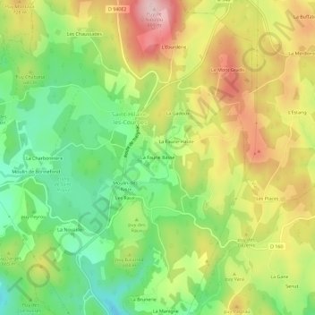
Name: La Faurie Basse topographic map, elevation, terrain.
Average elevation: 670 m
Minimum elevation: 559 m
Maximum elevation: 803 m
Thank you for supporting this site ❤️
Make a donation
Make a donation
Other topographic maps
Click on a map to view its topography, its elevation and its terrain.
Barrage de Monceaux-la-Virole
France > Nouvelle-Aquitaine > Corrèze > Saint-Hilaire-les-Courbes
Average elevation: 683 m