
Thank you for supporting this site ❤️
Make a donation
Make a donation
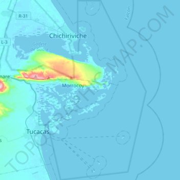
Morrocoy National Park topographic map
Click on the map to display elevation.
Thank you for supporting this site ❤️
Make a donation
Make a donation
Morrocoy National Park
The park's bays, mangroves, cays and islands sit in the shadow of the Chichiriviche hills, with elevations up to around 250 m. At 285 m high, Chichiriviche Hill is the highest point in the park. It stands amid the surrounding coastal environment of Tertiary-period coral origin, belonging to the Capadare - Agua Linda limestone geological formation.
Thank you for supporting this site ❤️
Make a donation
Make a donation
About this map
Name: Morrocoy National Park topographic map, elevation, terrain.
Average elevation: 10 m
Minimum elevation: -3 m
Maximum elevation: 283 m
Thank you for supporting this site ❤️
Make a donation
Make a donation