
Make a donation
Río Quintanilla topographic map
Click on the map to display elevation.
Make a donation
About this map
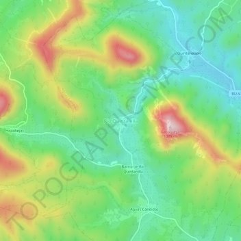
Name: Río Quintanilla topographic map, elevation, terrain.
Location: Río Quintanilla, Burgos, Castile and León, 09593, Spain (42.71116 -3.52841 42.75116 -3.48841)
Average elevation: 783 m
Minimum elevation: 629 m
Maximum elevation: 1,055 m
Make a donation
Other topographic maps
Click on a map to view its topography, its elevation and its terrain.
Burgos
At an elevation of 865 metres (2,838 ft), the city of Burgos lies in the transition zone between a Warm-summer Mediterranean climate (Köppen Csb) and an Oceanic climate (Köppen Cfb), with some continental influence resulting from its distance from the sea and higher altitude. Burgos' climate features chilly…
Average elevation: 907 m
Make a donation
Burgos
At an elevation of 865 metres (2,838 ft), the city of Burgos has a warm-summer Mediterranean climate (Köppen climate classification: Csb, with some continental influence resulting from its distance from the sea and higher altitude. It features chilly and windy winters, due to altitude and an inland location,…
Average elevation: 907 m
El Espinar
The documented history of El Espinar dates from the 11th century, even though the area has been inhabited since the Iron Age. In fact, in September 2016 was found the settlement of Canto Los Hierros in a nearby mountain located south of town, just at 1,700 metres above sea level. The settlement, dated back to…
Average elevation: 1,324 m
Make a donation
Segovia
Segovia is one of nine provinces that make up the autonomous region of Castile and León. Burgos and Valladolid lie to the north, Ávila to the west, Madrid to the south, and Soria to the east. The altitude of the province varies from 750 metres (2,461 feet) in the extreme northwest to a maximum of 2,430 m…
Average elevation: 1,143 m
Make a donation
Make a donation
Salamanca
With an altitude of over 800 meters, Salamanca has a warm-summer Mediterranean climate (Csb) according to the Köppen climate classification, with some cold semi-arid climate (BSk) climatic influences, resulting in large diurnal temperature variations, with hot summers and chilly winters, and nearly-semi-arid…
Average elevation: 812 m
Ciudad Rodrigo
At an elevation of 658 metres (2,159 ft) Ciudad Rodrigo has an inland Mediterranean climate (Köppen: Csb) characterised by cool, damp winters and warm, dry summers with relatively cool nights during the summer.
Average elevation: 709 m
Make a donation
Make a donation
Segovia
Segovia has a hot-summer Mediterranean climate (Csa in the Köppen climate classification) bordering on a cold semi-arid climate (BSk), resulting from the high altitude and the distance from the coast. The average annual temperature is 12.42 °C (54.4 °F), with an average low in January of 0.3 °C (32.5 °F)…
Average elevation: 1,143 m
Make a donation
Make a donation
Burgos
At an elevation of 865 metres (2,838 ft), the city of Burgos has a warm-summer Mediterranean climate (Köppen climate classification: Csb, with some continental influence resulting from its distance from the sea and higher altitude. It features chilly and windy winters, due to altitude and an inland location,…
Average elevation: 907 m
Make a donation
Make a donation
Ávila
Ávila is the capital and most populated municipality of the Province of Ávila, located in the autonomous community of Castile and León in Spain. Located in the centre of the Iberian Peninsula, to the north of the Sistema Central, it lies on the right bank of the Adaja and, at an elevation of over 1,130…
Average elevation: 1,157 m
Sierra de Guadarrama
The range runs southwest–northeast, extending from the province of Ávila in the southwest, through the Community of Madrid, to the province of Segovia in the northeast. The range measures approximately 80 kilometres (50 mi) in length. Its highest peak is Peñalara, 2,428 metres (7,966 ft) in elevation.
Average elevation: 1,153 m
Make a donation
Riaño
The two most common ascent routes are from Riaño and from Horcadas. Beginning from the viaduct across Riaño, a circular route to the summit is 8.2 km long with 675 m of elevation gain.
Average elevation: 1,313 m
Make a donation
Segovia
Segovia has a hot-summer Mediterranean climate (Csa in the Köppen climate classification) bordering on a cold semi-arid climate (BSk), resulting from the high altitude and the distance from the coast. The average annual temperature is 12.42 °C (54.4 °F), with an average low in January of 0.3 °C (32.5 °F)…
Average elevation: 1,143 m
Make a donation
Make a donation
Arévalo
It is located at an altitude of 820 meters and is near the junction of the two rivers Adaja and Arevalillo. Its encompassed area is 46.07 km2 and its population is 13.122. In medieval times, it was the head of the agricultural sector (Comunidad de Villa y Tierra) of the same name.
Average elevation: 845 m
Make a donation
Make a donation
Segovia
Segovia has a hot-summer Mediterranean climate (Csa in the Köppen climate classification) bordering on a cold semi-arid climate (BSk), resulting from the high altitude and the distance from the coast. The average annual temperature is 12.42 °C (54.4 °F), with an average low in January of 0.3 °C (32.5 °F)…
Average elevation: 1,143 m
Make a donation
Sierra de Atapuerca
Spain > Castile and León > Atapuerca
Encompassing 284,119 hectares (702,070 acres), the Atapuerca Mountains are a mid-altitude karstic range of small foothills around 1,080 m (3,540 ft) above sea level. They are located at the north-east corner of the Douro basin, to the south of the Cantabrian Mountains that run across northern Spain, and…
Average elevation: 991 m
Make a donation
Palencia
The region of Palencia has a Continental Mediterranean climate with cool winters, due to altitude (749 m) and isolation from maritime influences, chilly winds, including some days of snow in the winter and minimum temperatures usually below 0 °C (32 °F). Fog is frequent because of the Carrion river. Summers…
Average elevation: 794 m
Make a donation
Make a donation
Make a donation
Make a donation
Benavente
Benavente is characterized by a cold semi-arid climate in the Köppen climate classification (BSk) with continental influences due to the altitude of the municipality and its distance to the sea. The amount of winter frosts is increased, taking place even in spring, with consequential damage to some of the…
Average elevation: 716 m
Make a donation
Ávila
Ávila's position results in a warm summer mediterranean climate (Csb, according to the Köppen climate classification) bordering on a cold semi-arid climate (BSk) with warm summers and chilly winters with snowfalls. The hottest month, July, has an average temperature of 20.6 °C (69 °F), and the coldest…
Average elevation: 1,157 m
Make a donation