
Make a donation
El Espinar topographic map
Click on the map to display elevation.
Make a donation
El Espinar
The documented history of El Espinar dates from the 11th century, even though the area has been inhabited since the Iron Age. In fact, in September 2016 was found the settlement of Canto Los Hierros in a nearby mountain located south of town, just at 1,700 metres above sea level. The settlement, dated back to the Iron Age and later reused and expanded by the Romans, covered about 70 hectares and included about 100 houses, few traces of walls and quite a lot of iron items. This kind of ancient settlement at such a high altitude is considered unique within Europe.
Make a donation
About this map
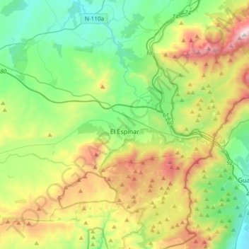
Name: El Espinar topographic map, elevation, terrain.
Location: El Espinar, Segovia, Castile and León, Spain (40.63680 -4.36471 40.80995 -4.07006)
Average elevation: 1,324 m
Minimum elevation: 903 m
Maximum elevation: 2,190 m
Make a donation
Other topographic maps
Click on a map to view its topography, its elevation and its terrain.
Make a donation
Make a donation
Make a donation
Make a donation
Make a donation
Make a donation
Make a donation
Yacimiento arqueológico La Edrada
Spain > Castile and León > El Bierzo > Cacabelos
Average elevation: 493 m
Make a donation
Sierra de Guadarrama
The range runs southwest–northeast, extending from the province of Ávila in the southwest, through the Community of Madrid, to the province of Segovia in the northeast. The range measures approximately 80 kilometres (50 mi) in length. Its highest peak is Peñalara, 2,428 metres (7,966 ft) in elevation.
Average elevation: 1,153 m
Make a donation
Make a donation
Make a donation
Make a donation
Make a donation
Make a donation
Make a donation
Make a donation
Make a donation
Make a donation
Make a donation
Make a donation
Make a donation
Poblado del Salto de Aldeadávila
Spain > Castile and León > Aldeadávila de la Ribera
Average elevation: 535 m
Make a donation
Make a donation
Make a donation
Make a donation