
Thank you for supporting this site ❤️
Make a donation
Make a donation
Porto Recanati topographic map
Click on the map to display elevation.
Thank you for supporting this site ❤️
Make a donation
Make a donation
About this map
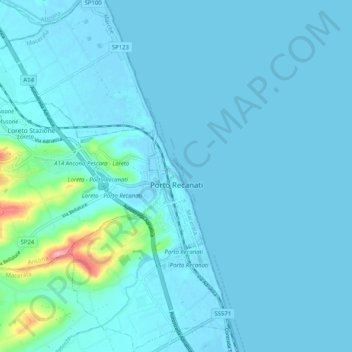
Name: Porto Recanati topographic map, elevation, terrain.
Location: Porto Recanati, Macerata, Marche, 62017, Italy (43.39994 13.60151 43.47394 13.67921)
Average elevation: 11 m
Minimum elevation: -2 m
Maximum elevation: 139 m
Thank you for supporting this site ❤️
Make a donation
Make a donation
Other topographic maps
Click on a map to view its topography, its elevation and its terrain.