
Thank you for supporting this site ❤️
Make a donation
Make a donation
Enggalwangi topographic map
Click on the map to display elevation.
Thank you for supporting this site ❤️
Make a donation
Make a donation
About this map
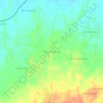
Name: Enggalwangi topographic map, elevation, terrain.
Location: Enggalwangi, Majalengka, West Java, Java, 45473, Indonesia (-6.75316 108.29611 -6.71316 108.33611)
Average elevation: 57 m
Minimum elevation: 40 m
Maximum elevation: 84 m
Thank you for supporting this site ❤️
Make a donation
Make a donation
Other topographic maps
Click on a map to view its topography, its elevation and its terrain.
lapangan GGM Majalengka
Indonesia > West Java > Majalengka > Majalengka Kulon
Average elevation: 109 m