
Thank you for supporting this site ❤️
Make a donation
Make a donation
Blackhawk Peak topographic map
Click on the map to display elevation.
Thank you for supporting this site ❤️
Make a donation
Make a donation
About this map
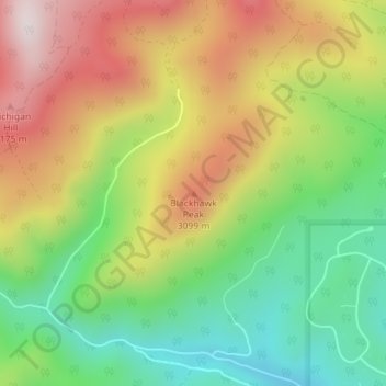
Name: Blackhawk Peak topographic map, elevation, terrain.
Average elevation: 2,911 m
Minimum elevation: 2,636 m
Maximum elevation: 3,240 m
Thank you for supporting this site ❤️
Make a donation
Make a donation
Other topographic maps
Click on a map to view its topography, its elevation and its terrain.
East Portal Distributed Camping Area
United States > Colorado > Gilpin County
Average elevation: 3,041 m
Thank you for supporting this site ❤️
Make a donation
Make a donation