
Thank you for supporting this site ❤️
Make a donation
Make a donation
San Agustinillo topographic map
Click on the map to display elevation.
Thank you for supporting this site ❤️
Make a donation
Make a donation
About this map
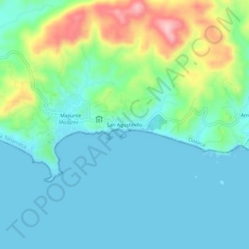
Name: San Agustinillo topographic map, elevation, terrain.
Location: San Agustinillo, Santa María Tonameca, Oaxaca, 70947, México (15.64611 -96.56464 15.68611 -96.52464)
Average elevation: 45 m
Minimum elevation: 0 m
Maximum elevation: 189 m
Thank you for supporting this site ❤️
Make a donation
Make a donation
Other topographic maps
Click on a map to view its topography, its elevation and its terrain.