
Make a donation
Exogi topographic map
Click on the map to display elevation.
Make a donation
About this map
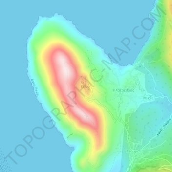
Name: Exogi topographic map, elevation, terrain.
Average elevation: 102 m
Minimum elevation: 0 m
Maximum elevation: 517 m
Make a donation
Other topographic maps
Click on a map to view its topography, its elevation and its terrain.
Pistros
Greece > Peloponnese, Western Greece and the Ionian > Ithaca Regional Unit
Average elevation: 3 m
Ithaca
Greece > Peloponnese, Western Greece and the Ionian > Ithaca Regional Unit > Exogi
It has sometimes been argued that this description does not match the topography of modern Ithaca. Three features of the description have been seen as especially problematic. First, Ithaca is described as "low-lying" (χθαμαλή), but Ithaca is mountainous. Second, the words "farthest out to sea, towards…
Average elevation: 109 m
Ithaca
Greece > Peloponnese, Western Greece and the Ionian > Ithaca Regional Unit > Frikes
It has sometimes been argued that this description does not match the topography of modern Ithaca. Three features of the description have been seen as especially problematic. First, Ithaca is described as "low-lying" (χθαμαλή), but Ithaca is mountainous. Second, the words "farthest out to sea, towards…
Average elevation: 109 m