
Thank you for supporting this site ❤️
Make a donation
Make a donation
Onekaka topographic map
Click on the map to display elevation.
Thank you for supporting this site ❤️
Make a donation
Make a donation
About this map
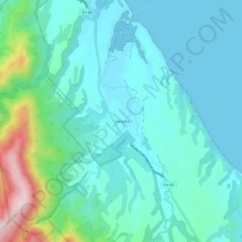
Name: Onekaka topographic map, elevation, terrain.
Location: Onekaka, Tasman, 7182, New Zealand (-40.78413 172.68827 -40.74413 172.72827)
Average elevation: 73 m
Minimum elevation: 0 m
Maximum elevation: 385 m
Thank you for supporting this site ❤️
Make a donation
Make a donation
Other topographic maps
Click on a map to view its topography, its elevation and its terrain.
Spenser Mountains
New Zealand > Tasman > Hurunui District
The Spenser Mountains is a topographic landform in the northern South Island of New Zealand. Located at the southern end of the Nelson Lakes National Park and north of the Lewis Pass they form a natural border between the Canterbury and Tasman regions. Several peaks are named after characters in Edmund…
Average elevation: 1,310 m
Thank you for supporting this site ❤️
Make a donation
Make a donation
Thank you for supporting this site ❤️
Make a donation
Make a donation