
Thank you for supporting this site ❤️
Make a donation
Make a donation
Le Pouyalet topographic map
Click on the map to display elevation.
Thank you for supporting this site ❤️
Make a donation
Make a donation
About this map
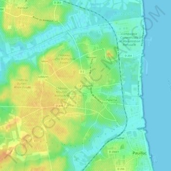
Name: Le Pouyalet topographic map, elevation, terrain.
Average elevation: 13 m
Minimum elevation: 0 m
Maximum elevation: 31 m
Thank you for supporting this site ❤️
Make a donation
Make a donation
Other topographic maps
Click on a map to view its topography, its elevation and its terrain.
Château Lafite-Rothschild
France > Nouvelle-Aquitaine > Gironde > Pauillac > Mousset
Average elevation: 14 m