
Thank you for supporting this site ❤️
Make a donation
Make a donation
Tanjungpakis topographic map
Click on the map to display elevation.
Thank you for supporting this site ❤️
Make a donation
Make a donation
About this map
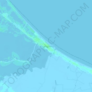
Name: Tanjungpakis topographic map, elevation, terrain.
Location: Tanjungpakis, Karawang, West Java, Java, Indonesia (-5.99469 107.10923 -5.95469 107.14923)
Average elevation: 0 m
Minimum elevation: -3 m
Maximum elevation: 6 m
Thank you for supporting this site ❤️
Make a donation
Make a donation
Other topographic maps
Click on a map to view its topography, its elevation and its terrain.
Thank you for supporting this site ❤️
Make a donation
Make a donation
Thank you for supporting this site ❤️
Make a donation
Make a donation
Wonderland Adventure Waterpark Galuh Mas Karawang
Indonesia > West Java > Karawang > Sukaluyu
Average elevation: 17 m
Thank you for supporting this site ❤️
Make a donation
Make a donation