
Thank you for supporting this site ❤️
Make a donation
Make a donation
Deutenbach topographic map
Click on the map to display elevation.
Thank you for supporting this site ❤️
Make a donation
Make a donation
About this map
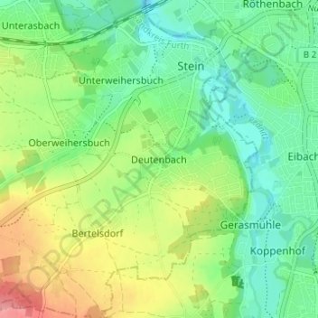
Name: Deutenbach topographic map, elevation, terrain.
Location: Deutenbach, Stein, Fürth (district), Bavaria, 90547, Germany (49.38215 10.98682 49.42215 11.02682)
Average elevation: 326 m
Minimum elevation: 291 m
Maximum elevation: 388 m
Thank you for supporting this site ❤️
Make a donation
Make a donation