
Thank you for supporting this site ❤️
Make a donation
Make a donation
Spiez topographic map
Click on the map to display elevation.
Thank you for supporting this site ❤️
Make a donation
Make a donation
About this map
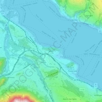
Name: Spiez topographic map, elevation, terrain.
Average elevation: 655 m
Minimum elevation: 549 m
Maximum elevation: 1,544 m
Thank you for supporting this site ❤️
Make a donation
Make a donation
Other topographic maps
Click on a map to view its topography, its elevation and its terrain.
Kiental
Switzerland > Bern > Frutigen-Niedersimmental administrative district > Reichenbach im Kandertal
Average elevation: 1,363 m