
Thank you for supporting this site ❤️
Make a donation
Make a donation
Baitushan topographic map
Click on the map to display elevation.
Thank you for supporting this site ❤️
Make a donation
Make a donation
About this map
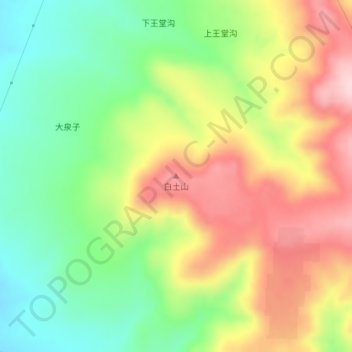
Name: Baitushan topographic map, elevation, terrain.
Location: Baitushan, Ulanqab City, Inner Mongolia, China (41.09853 113.46969 41.09863 113.46979)
Average elevation: 1,555 m
Minimum elevation: 1,450 m
Maximum elevation: 1,679 m
Thank you for supporting this site ❤️
Make a donation
Make a donation
Other topographic maps
Click on a map to view its topography, its elevation and its terrain.
Dorbod Banner
China > Inner Mongolia > Ulanqab City
The banner is located along the northern foothills of the Yin Mountains, and has an average elevation of 1,400 metres (4,600 ft).[3] Most of the banner's area is grassland.[3]
Average elevation: 1,294 m