
Thank you for supporting this site ❤️
Make a donation
Make a donation
Plimoth Commons topographic map
Click on the map to display elevation.
Thank you for supporting this site ❤️
Make a donation
Make a donation
About this map
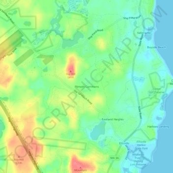
Name: Plimoth Commons topographic map, elevation, terrain.
Average elevation: 24 m
Minimum elevation: 0 m
Maximum elevation: 64 m
Thank you for supporting this site ❤️
Make a donation
Make a donation
Other topographic maps
Click on a map to view its topography, its elevation and its terrain.
Fresh Pond
United States > Massachusetts > Plymouth County > Plymouth > Cedar Bushes
Average elevation: 14 m
Great Herring Pond
United States > Massachusetts > Plymouth County > Plymouth > Cedarville
Average elevation: 24 m