
Thank you for supporting this site ❤️
Make a donation
Make a donation
Mount Arvon topographic map
Click on the map to display elevation.
Thank you for supporting this site ❤️
Make a donation
Make a donation
Mount Arvon
Mount Arvon (/ɑːrvɒn/ ARR-vahn) at 1,979 feet (603 m), is the highest natural point in the U.S. state of Michigan. Located in L'Anse Township, Baraga County, Mount Arvon is part of the Huron Mountains. It rises about eight miles (13 km) south of Lake Superior (elevation 591 feet [180 m]). On the list of highest natural points in each U.S. state, Mount Arvon ranks 38th. It is the highest natural point in the East North Central states.
Thank you for supporting this site ❤️
Make a donation
Make a donation
About this map
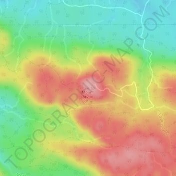
Name: Mount Arvon topographic map, elevation, terrain.
Average elevation: 526 m
Minimum elevation: 455 m
Maximum elevation: 600 m
Thank you for supporting this site ❤️
Make a donation
Make a donation