
Thank you for supporting this site ❤️
Make a donation
Make a donation
Serres topographic map
Click on the map to display elevation.
Thank you for supporting this site ❤️
Make a donation
Make a donation
Serres
Serres is one of the administrative and economic centers of Northern Greece. The city is situated in a fertile plain at an elevation of about 70 metres (230 feet), some 24 kilometres (15 miles) northeast of the Strymon river and 69 km (43 mi) north-east of Thessaloniki, respectively. Serres' official municipal population was 70,703 in 2021.
Thank you for supporting this site ❤️
Make a donation
Make a donation
About this map
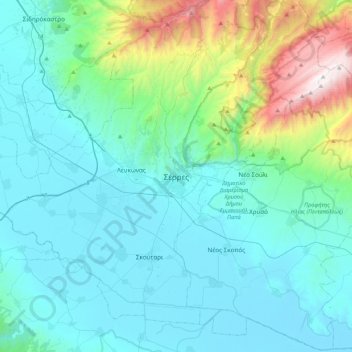
Name: Serres topographic map, elevation, terrain.
Average elevation: 317 m
Minimum elevation: -1 m
Maximum elevation: 1,951 m
Thank you for supporting this site ❤️
Make a donation
Make a donation
Other topographic maps
Click on a map to view its topography, its elevation and its terrain.
Kerkini Lake
Greece > Central Macedonia > Serres Regional Unit > Iraklia Municipal Unit
Average elevation: 124 m