
Thank you for supporting this site ❤️
Make a donation
Make a donation
Prospect topographic map
Click on the map to display elevation.
Thank you for supporting this site ❤️
Make a donation
Make a donation
About this map
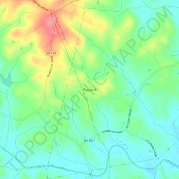
Name: Prospect topographic map, elevation, terrain.
Location: Prospect, Franklin County, Georgia, United States (34.42344 -83.40794 34.46344 -83.36794)
Average elevation: 233 m
Minimum elevation: 199 m
Maximum elevation: 300 m
Thank you for supporting this site ❤️
Make a donation
Make a donation
Other topographic maps
Click on a map to view its topography, its elevation and its terrain.