
Thank you for supporting this site ❤️
Make a donation
Make a donation
Indawar topographic map
Click on the map to display elevation.
Thank you for supporting this site ❤️
Make a donation
Make a donation
About this map
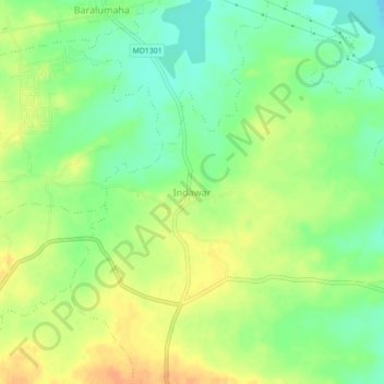
Name: Indawar topographic map, elevation, terrain.
Location: Indawar, Manpur Tahsil, Umaria, Madhya Pradesh, India (23.97545 80.99751 24.01545 81.03751)
Average elevation: 351 m
Minimum elevation: 333 m
Maximum elevation: 368 m
Thank you for supporting this site ❤️
Make a donation
Make a donation
Other topographic maps
Click on a map to view its topography, its elevation and its terrain.
Bandhavgarh National Park/Tiger Reserve
India > Madhya Pradesh > Manpur Tahsil
Average elevation: 443 m