
Thank you for supporting this site ❤️
Make a donation
Make a donation
Danawarih topographic map
Click on the map to display elevation.
Thank you for supporting this site ❤️
Make a donation
Make a donation
About this map
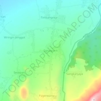
Name: Danawarih topographic map, elevation, terrain.
Location: Danawarih, Tegal, Central Java, Java, 52464, Indonesia (-7.09200 109.10750 -7.05200 109.14750)
Average elevation: 238 m
Minimum elevation: 113 m
Maximum elevation: 562 m
Thank you for supporting this site ❤️
Make a donation
Make a donation