
Thank you for supporting this site ❤️
Make a donation
Make a donation
Clarke Creek topographic map
Click on the map to display elevation.
Thank you for supporting this site ❤️
Make a donation
Make a donation
About this map
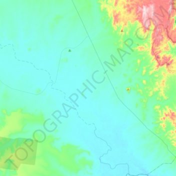
Name: Clarke Creek topographic map, elevation, terrain.
Location: Clarke Creek, Isaac Regional, Queensland, Australia (-22.87912 149.14706 -22.57230 149.44864)
Average elevation: 169 m
Minimum elevation: 89 m
Maximum elevation: 615 m
Thank you for supporting this site ❤️
Make a donation
Make a donation
Other topographic maps
Click on a map to view its topography, its elevation and its terrain.