
Thank you for supporting this site ❤️
Make a donation
Make a donation
Palopo topographic map
Click on the map to display elevation.
Thank you for supporting this site ❤️
Make a donation
Make a donation
About this map
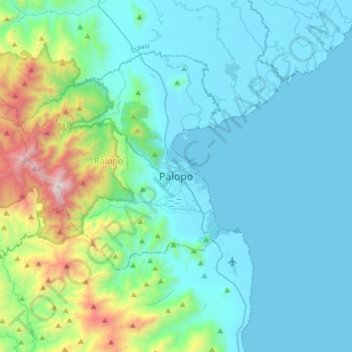
Name: Palopo topographic map, elevation, terrain.
Location: Palopo, Sulawesi du Sud, 91921, Indonésie (-3.15963 120.03207 -2.83963 120.35207)
Average elevation: 298 m
Minimum elevation: 0 m
Maximum elevation: 1,895 m
Thank you for supporting this site ❤️
Make a donation
Make a donation