
Tuyên Quang Province topographic map
Interactive map
Click on the map to display elevation.
Tuyên Quang Province
The province has widely varying topography covering high mountains deep valleys; the dominant elevation of the province is in the range 200–600 metres (660–1,970 ft). The province is in the foothills of the Northern Highlands, which forms a broad crescent around the Tonkin Delta; its southern part has narrow river basins and mountain ranges (elevation below 300 metres (980 ft)) and the northern part, particularly in Chiêm Hoá and Nà Hang districts the slopes are steep with hills taller than 1,400 metres (4,600 ft) (the highest mountain is Cham Chu at 1,589 metres (5,213 ft)). The Tam Dao range is located in this province.
About this map
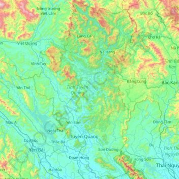
Name: Tuyên Quang Province topographic map, elevation, terrain.
Location: Tuyên Quang Province, Vietnam (21.49759 104.84860 22.69597 105.59831)
Average elevation: 318 m
Minimum elevation: 12 m
Maximum elevation: 2,233 m
Other topographic maps
Click on a map to view its topography, its elevation and its terrain.
Ho Chi Minh City
Vietnam > Ho Chi Minh City > Ho Chi Minh City
Ho Chi Minh City is located in the south-eastern region of Vietnam, 1,760 km (1,090 mi) south of Hanoi. The average elevation is 19 metres (62 ft) above sea level. It borders Tây Ninh Province and Bình Dương Province to the north, Đồng Nai Province and Bà Rịa–Vũng Tàu Province to the east, Long…
Average elevation: 6 m