
Thank you for supporting this site ❤️
Make a donation
Make a donation
Pouch topographic map
Click on the map to display elevation.
Thank you for supporting this site ❤️
Make a donation
Make a donation
Pouch
Blasonierung: „In Silber vom unteren Schildrand steigend drei langgestielte grüne Eichenblätter, vor dem mittleren – in gleicher Höhe – ein schwarz gefugtes rotes Stadttor mit zwei beknauften spitzbedachten Turmaufsätzen, vier Rundbogenfensteröffnungen (2:2) und einer Rundbogentoröffnung.“
Thank you for supporting this site ❤️
Make a donation
Make a donation
About this map
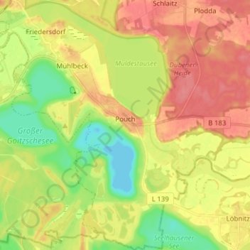
Name: Pouch topographic map, elevation, terrain.
Average elevation: 81 m
Minimum elevation: 48 m
Maximum elevation: 110 m
Thank you for supporting this site ❤️
Make a donation
Make a donation
Other topographic maps
Click on a map to view its topography, its elevation and its terrain.
Thank you for supporting this site ❤️
Make a donation
Make a donation
Thank you for supporting this site ❤️
Make a donation
Make a donation
Osternienburg
Deutschland > Sachsen-Anhalt > Anhalt-Bitterfeld > Osternienburger Land
Average elevation: 70 m
Thank you for supporting this site ❤️
Make a donation
Make a donation
Thank you for supporting this site ❤️
Make a donation
Make a donation