
Thank you for supporting this site ❤️
Make a donation
Make a donation
Echandens topographic map
Click on the map to display elevation.
Thank you for supporting this site ❤️
Make a donation
Make a donation
About this map
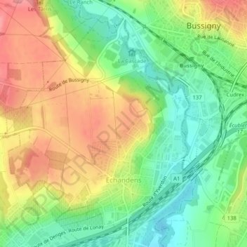
Name: Echandens topographic map, elevation, terrain.
Location: Echandens, District de Morges, Vaud, 1026, Suisse (46.52894 6.52169 46.55209 6.55260)
Average elevation: 426 m
Minimum elevation: 379 m
Maximum elevation: 480 m
Thank you for supporting this site ❤️
Make a donation
Make a donation
Other topographic maps
Click on a map to view its topography, its elevation and its terrain.