
Oberndorf topographic map
Interactive map
Click on the map to display elevation.
About this map
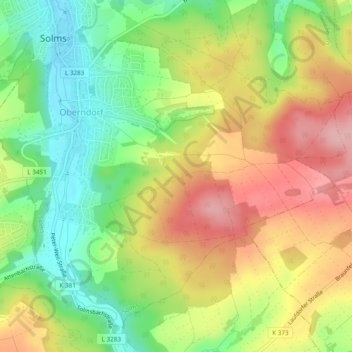
Name: Oberndorf topographic map, elevation, terrain.
Location: Oberndorf, Solms, Lahn-Dill-Kreis, Hessen, Deutschland (50.50829 8.39781 50.53459 8.44571)
Average elevation: 221 m
Minimum elevation: 149 m
Maximum elevation: 300 m
Other topographic maps
Click on a map to view its topography, its elevation and its terrain.
Niederbiel
Deutschland > Hessen > Lahn-Dill-Kreis > Solms
Niederbiel, Solms, Lahn-Dill-Kreis, Hessen, Deutschland
Average elevation: 213 m